(click link above for Idaho's Website where this info was taken from)
*Note: Not ALL byways are listed as some are not all paved

Clicking on the Scenic Byway TITLE(s) below should take you
to the location in Google Maps where you can study more
closely - such as in satellite view etc.
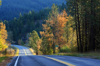
From Ashton, Idaho, the Mesa
Falls Scenic Byway heads northeast into the lush landscape of the Targhee
National Forest. It’s a loop that runs for nearly thirty impressive miles all
the way to the Island Park area.This byway includes the popular Warm River
campground and two of the most spectacular waterfalls in the West — lower and
upper Mesa Falls. At the upper falls you can stop at the historic Big Falls
interpretive center to learn about the geology and history of the area.
THINGS TO KNOW
 |
| Photo by BQ |
·
Location: Beginning at Idaho 47 in Ashton, the
route travels northeast 12.4 miles to the old Bear Gulch Ski Area site, then
northwest along Forest Service Route 294 ending at US 20.
·
Attractions include Upper Mesa Falls, Lower Mesa
Falls, and Harriman State Park.
·
Drive Time: 28.7 miles. Allow 1 hour.
·
Plan ahead to ensure a safe and enjoyable trip
(fill up on gas, pack water and food, etc.).
Hells Canyon Scenic Byway offers
breathtaking views of the canyon while winding its way along the east side of
the massive rift that separates Idaho from neighboring Oregon. Towering cliffs
of black and green basalt hang high above the Snake River and its sandy
beaches.
 THINGS TO KNOW
·
Location: Hells Canyon Road from Oxbow Bridge
near Copperfield, Oregon, north along the Idaho side of the Snake River to
Hells Canyon Dam.
·
Guided float and jet boat trips on the Snake
River are recommended.
·
Attractions include Hells Canyon National
Recreation Area, the Snake River, and Hells Canyon Dam.
·
Drive Time: 22 miles. Allow 3 hours round trip
from Cambridge.
·
Discover pictographs and petroglyphs on the
walls of the canyon from early Indian settlements.
·
Hells Canyon Road is a narrow, winding two-lane
paved road with several steep grades.
·
Plan ahead to ensure a safe and enjoyable trip
(fill up on gas, pack water and food, etc.).
·
Allow 3 hours round trip from Cambridge.
Having the distinction of being
the 100th National Forest Scenic Byway, Sawtooth Scenic Byway rolls north
through fertile agricultural land then on through the resort towns of Hailey,
Ketchum, and Sun Valley.
THINGS TO KNOW
 |
| Photo by Bart |
·
Location: Idaho 75 north to Stanley from
Shoshone.
·
Attractions include Sawtooth National Recreation
Area, Redfish Lake, and Sun Valley Resort.
·
Drive Time: 115.7 miles. Allow 3 hours.
·
Full services available in Hailey and Ketchum;
partial services in Shoshone and Stanley. Plan ahead to ensure a safe and
enjoyable trip (fill up on gas, pack water and food, etc.).
Thousand Springs Scenic Byway
provides a glimpse into the remarkable geology and history of the breathtaking
Snake River Canyon.
THINGS TO KNOW
 |
| Photo by BQ |
·
Location: Begins at Interstate 84 near Bliss and
follows US 30 southeast through Twin Falls to Idaho 50, then north on Idaho 50
to I-84. Also US 93 from Twin Falls
north to I-84.
·
The best time to see Shoshone Falls is in early
spring.
·
Attractions include Thousand Springs State Park
Complex–a series of five parks; Hagerman Valley; the Snake River; Hagerman
Fossil Beds National Monument; Thousand Springs; Herrett Center Planetarium,
Museum & Observatory in Twin Falls; Perrine Bridge & Canyon Rim Trail
System; Shoshone Falls; and historic downtown Twin Falls.
·
Drive Time:
67.8 miles. Allow 1.5 hours.
·
Plan ahead to ensure a safe and enjoyable trip
(fill up on gas, pack water and food, etc.).
·
Full services available in Bliss, Hagerman,
Buhl, Kimberly, and Twin Falls; partial services in Filer.
The Teton Scenic Byway runs
along the western slopes of the spectacular Teton Range. It’s a 70-mile trip
that includes breathtaking vistas, rivers, historic sites and access to the
Grand Targhee Resort. In the Teton Valley there’s even a bike trail that runs
parallel to the byway and an annual balloon festival in the quaint town of
Driggs. Further north along this route the Upper Snake River Valley is full of
fields of potatoes and other crops.
THINGS TO KNOW
 |
| Photo by BQ |
·
Location: Begins on Idaho 31 at Swan Valley
northeast to Idaho 33 at Victor, then north on Idaho 33 to Idaho 32, north on
Idaho 32 to Idaho 47, and west on Idaho 47 to US 20 at Ashton
·
Drive Time: 68.9 miles. Allow 2.5 hours.
·
The road often has a snow floor in winter.
·
Attractions include the Teton Mountains, Targhee
National Forest, and Grand Targhee Resort.
·
Plan ahead to ensure a safe and enjoyable trip
(fill up on gas, pack water and food, etc.).
Lake Coeur d’Alene Scenic Byway
traverses an area where the lakes, mountains, and beautiful summer weather have
made it one of the most famous summer playgrounds and resort destinations in
the Pacific Northwest. It’s also home to a variety of wildlife, including
moose, deer, elk, bear and several bird species.
THINGS TO KNOW
 |
| Photo by Bart with BQ 29-June-2010 |
·
Location: Beginning at the junction of
Interstate 90 and Idaho 97, the route travels south along the eastern shoreline
of Lake Coeur d’Alene, and ends at Idaho 3, where it meets the White Pine
Scenic Byway and its southern route to the Palouse.
·
Wildlife is expansive and diverse throughout the
year, eagle watching at its peak in December and January. Summer attractions
include camping, boating, water sports, cycling, bird watching, and fishing.
During the fall you can enjoy the leaves changing colors along the lake.
·
Attractions include Lake Coeur d'Alene, Mineral
Ridge Recreation Trail, Coeur d'Alene River, Trail of the Coeur d'Alenes, zip
lining, campgrounds, public beach and the town of Harrison.
·
Drive Time: 35.8 miles - 1.5 hours. Allow more
time to experience the outdoor side trips and Harrison's amenities.
·
Plan ahead to ensure a safe and enjoyable trip
(fill up on gas, pack water and food, etc.).
Northwest Passage Scenic Byway
is Idaho’s longest byway, which at 202 miles, follows the route Lewis and Clark
took through north-central Idaho. This beautiful route begins on US 12 at
Lewiston, and traverses the winding Clearwater RiverCanyon. At Kooskia the
byway splits with one segment heading south on Idaho Highway 13 toward the
Camas Prairie and the town of Grangeville. Another segment continues east on US
12 along the Middle Fork of the Clearwater River, and the Lochsa Wild and
Scenic River, through a magnificent wilderness culminating at the Lolo Pass
Visitor Center.
THINGS TO KNOW
 |
| Photo by BQ |
·
Location: Begins in Lewiston and follows US 12
northeast to the Idaho–Montana border; also follows Idaho 13 from Kooskia to
Grangeville and the junction of US 95.
·
Boating, fishing, heritage, and wildlife viewing
is available year-round. Whitewater opportunities run in the spring and summer.
·
Attractions include the Tsceminicum sculpture,
Nez Perce National Historical Park Visitor Center, and Hells Gate State Park.
·
Drive Time:
Lewiston to Montana, 175 miles, allow 4 hours. Kooskia to Grangeville,
27 miles, allow 40 minutes.
·
Plan ahead to ensure a safe and enjoyable trip
(fill up on gas, pack water and food, etc.).
·
Winter driving conditions may include black ice
in the canyons and snow-covered roads at higher elevations.
Following the same path Lewis
and Clark traveled over two centuries ago, Salmon River Scenic Byway follows
the Salmon River through the Salmon-Challis National Forest, serving as a
natural pathway into Idaho’s rugged backcountry.
 THINGS TO KNOW

·
Location: From the Montana state line south on
U.S. 93 to Challis, then west to Stanley on Idaho 75.
·
Attractions include Sacajawea Interpretive
Center; Salmon spawning beds at Indian Riffles; Land of the Yankee Fork
Interpretive Center; Tower Rock; Continental Divide National Scenic Trail;
Lewis and Clark National Historic Trail; Nez Perce (Nee Mee Poo) National
Historic Trail; Salmon Wild & Scenic River; Middle Fork Salmon Wild &
Scenic River; Frank Church River of No Return Wilderness; Salmon-Challis and
Sawtooth National Forests; natural hot springs, and ghost towns.
·
161.7 miles. Allow 3.5 hours.
·
Full services in Challis and Salmon. Partial
services in Stanley and North Fork. Plan ahead to ensure a safe and enjoyable
trip (fill up on gas, pack water and food, etc.).
Peaks to Craters Scenic Byway
features some of the most diverse stretches of road in Idaho, with massive lava
flows, wetlands, high desert and some of Idaho’s tallest mountains. The byway
runs right along the magnificent Lost River Mountain Range which features nine
of Idaho’s highest peaks including the tallest in the state, Mount Borah.
THINGS TO KNOW
 |
| Photo by BQ @ Craters Of The Moon Natl Mon |
·
Location: Junction of Idaho 75 and US 20 to
Carey. US 93 to Arco, continuing on US 93 to Junction of US 93 and Idaho 75.
·
Attractions include Craters of the Moon National
Monument and Preserve, Mt. Borah, and Mackay Dam and Reservoir.
·
Drive Time: Length: 140 miles. Allow 3 hours
·
Plan ahead to ensure a safe and enjoyable trip
(fill up on gas, pack water and food, etc.).
·
Winter weather can be severe. Check conditions
before traveling.
The Sacajawea Historic Byway
offers a wealth of engaging stories and Native American history, as well as
compelling views. This eastern Idaho byway is a history-filled corridor. From
Sacajawea and the Lewis and Clark expedition to the mining boom of the late
1800s, there are many stories to discover on this drive. Along the way you can
see charcoal kilns used over a 130 years ago to process lead and silver ore.
You can also visit the former mining community of Gilmore, now virtually a
ghost town.
 THINGS TO KNOW

·
Location: Begins at the intersection of
Interstate 15 & Idaho 33 at Exit 143, follows Idaho 33 about 12 miles west
to its junction with Idaho 28, and follows Idaho 28 northwest for 120 miles to
Salmon, Idaho.
·
Attractions include the Continental Divide, Charcoal
Kilns, and Meadow Lake.
·
Drive Time: 132 miles. About 2.5 hours.
·
Plan ahead to ensure a safe and enjoyable trip
(fill up on gas, pack water and food, etc.).
Starting west of Boise, the
Payette River Scenic Byway heads north on Idaho 55 passing the Payette River
and the Boise and Payette National Forests. Other great stops along this drive
include Cascade Reservoir, Smiths Ferry, Roseberry (one mile east of the byway
on Roseberry Road at Donnelly), the city of McCall, and Ponderosa State Park.
 THINGS TO KNOW

·
Location: From the junction of US 95 at New
Meadows along Idaho 55 south to Idaho 44 west of Boise.
·
Drive Time: 111.7 miles. Allow about 2 hours.
·
Full services available in Boise, Cascade,
Donnelly, and McCall; partial services in Horseshoe Bend.
·
Plan ahead to ensure a safe and enjoyable trip
(fill up on gas, pack water and food, etc.).
The Ponderosa Pine Scenic Byway
winds through the Boise National Forest, passing through dense forests of pine,
across high mountain valleys, and along portions of the Boise River, Lucky Peak
Lake, and the South Fork of the Payette River.
THINGS TO KNOW
 |
| Photo by BQ |
·
Location: From Boise on Idaho 21 northeast to
the junction of Idaho 75 at Stanley.
·
Attractions include Lucky Peak and Arrow Rock
Reservoirs; Lucky Peak State Park; Idaho City; Sawtooth Wilderness; Granite
Creek Interpretive Trail; Lowman Fire Interpretive Signs; Kirkham Hot Springs;
Stanley Lake; Boise, Salmon- Challis and Sawtooth National Forests; Forest
Service/BLM Visitor Information Center in Boise, and the Idaho City, Lowman,
and Stanley Ranger Stations.
·
Drive Time: 130.9 miles. Allow 3 hours.
·
Full services in Boise and Idaho City. Limited
services in Lowman and Stanley.
·
Plan ahead to ensure a safe and enjoyable trip
(fill up on gas, pack water and food, etc.).
Offering a panoramic,
breathtaking view of the Owyhee Mountains, the Western Heritage Historic Byway
encompasses vast sagebrush lands and canyon rims of the Snake River. Birds of
prey are often spotted in this area, but the best time to spot them soaring
through the skies is March to late June.
THINGS TO KNOW
 |
| Swan Falls Dam |
·
Location: From Meridian, Idaho Highway 69 begins
on the southbound road from exit 44 of I-84 and runs for 8 miles to East Avalon
Avenue in Kuna. Turn south on Swan Falls Road and continue for 21 miles through
the National Conservation Area (NCA) Birds of Prey to Swan Falls Dam.
·
Attractions include the Kuna Visitor Center;
Silver Trail at Indian Creek; Pioneer Cemetery; Initial Point; Snake River
Birds of Prey National Conservation Area; Dedication Point; Snake River Canyon
Rim, Swan Falls Dam Historic Powerhouse and Museum, Celebration Park, Owhyee
County Museum.
·
Drive Time: 47 miles. Allow 1.5 hours for
travel.
·
Full services are available in Kuna. Plan ahead
to ensure a safe and enjoyable trip (fill up on gas, pack water and food,
etc.).
Offering panoramic views of farm
land, extensive forests, rivers, and mountains, White Pine Scenic Byway crosses
the picturesque St. Maries and St. Joe Rivers before meandering south through
the St. Joe National Forest and the rolling hills of the Palouse region.
 THINGS TO KNOW

·
Location: From the junction of Interstate 90 and
Idaho 3, south on Idaho 3 to Idaho 6, then southwest to U.S. 95 at Potlatch.
·
Attractions include Old Mission State Park, St.
Joe National Forest, and Palouse Divide Nordic Ski Area.
·
Camping, Fishing, Hiking, and several towns to
explore.
·
The White Pine Byway (Idaho 3) runs through the
St. Joe National Forest and the entrance to the St. Joe Scenic Byway,
intersecting with the Lake Coeur d’Alene Scenic Byway (Idaho 97). Then follows
along the Coeur d’Alene River until it intersects with Interstate 90.
·
Drive Time: 82.8 miles. Allows 2 hours.
·
Plan ahead to ensure a safe and enjoyable trip
(fill up on gas, pack water and food, etc.).
Offering some of Idaho’s most
spectacular water views, the Pend Oreille Scenic Byway meanders eastward to the
Montana state line across farmlands, through river deltas, and along the rocky
northern shores of Lake Pend Oreille.
 THINGS TO KNOW

·
Location: Begins at US 95 north of Sandpoint and
follows Idaho 200 to the Montana state line.
·
Drive Time:
33.4 miles. Allow 1.5 hours to enjoy the scenery and interpretive
information.
·
Attractions include Lake Pend Oreille, Clark
Fork River, and Schweitzer Ski Area.
·
Plan ahead to ensure a safe and enjoyable trip
(fill up on gas, pack water and food, etc.).
Part of the International
Selkirk Loop, Wild Horse Trail Scenic Byway heads north along the eastern side
of the Selkirk Mountains, following the Kootenai Tribe’s historic path to
fishing grounds at Lake Pend Oreille.
 THINGS TO KNOW
·
Location: Begins on U.S. 95 in downtown
Sandpoint and follows U.S. 95 north through Bonners Ferry to the junction of
U.S. 95 and Idaho 1, then proceeds north on Idaho 1 to the International Border
at Porthill.
·
Fall colors on this byway are particularly
dramatic.
·
Attractions include Lake Pend Oreille, Kootenai
National Wildlife Refuge, and the Kootenai Sturgeon Hatchery.
·
Drive Time: 48.2 miles from Sandpoint to
junction of U.S. 95/Idaho 1, 11 miles to the International Border at Porthill.
Allow 1.5 hours.
·
This is part of the International Selkirk Loop,
designated as North America's only International Scenic Byway.
·
Once in the Selkirk Mountains, check out hiking,
fishing, Nordic skiing, and snowmobiling.
·
Plan ahead to ensure a safe and enjoyable trip
(fill up on gas, pack water and food, etc.).
Following the old miner’s supply
route from Banks to Lowman alongside the churning waters of the South Fork of
the Payette River, Wildlife Canyon Scenic Byway goes through a canyon cut deep
into the heart of the Idaho mountains. This route is considered some of the
most powerful canyon scenery offered in the state.
 THINGS TO KNOW

·
Location: The route travels along the
Banks-Lowman road. It can be accessed either at Banks along Idaho 55 or at
Lowman along Idaho 21. Either point of access brings the traveler back to a
route leading to Boise.
·
Attractions include the South Fork of the
Payette River, which offers world-class rafting and kayaking. The winter range
for elk is located within a five-mile section in the middle of the route near
the Danskin river-access point. In 2005 two turnouts with wildlife viewing
scopes were added. Visitors are treated to large herds along this area during
winter and spring months.
·
Drive Time: 33 miles. Allow one hour. Allow 3
hours for the loop from Boise and back.
·
The migratory and nesting route for Canada Geese
is located here also. Commercial rafting companies offer trips down the river.
·
Plan ahead to ensure a safe and enjoyable trip
(fill up on gas, pack water and food, etc.).
·
Services are available in Garden Valley; limited
services are available in Banks, Crouch, and Lowman. Plan ahead to ensure a
safe and enjoyable trip (fill up on gas, pack water and food, etc.).
Although you're linking to maps in Google, I've created these routes in Garmin BaseCamp and for anyone interested, I would be happy to share the .gpx file(s). Please email me.
This is a great collection of roads!
ReplyDelete